Flood Estimation Handbook Web Service
The FEH Web Service delivers catchment descriptors and rainfall data to support the methods outlined in the Flood Estimation Handbook (FEH), and implemented in the FEH software, for estimating floods and site runoff rates across the UK.
Get started in England, Scotland & Wales or Northern Ireland
What's new
![]() For any catchment above 0.5km²:
For any catchment above 0.5km²:
- Catchment descriptors for flood estimation
- Rainfall rarity/depth data (using the FEH22, FEH13 and legacy FEH99 DDF models)
- Learn more
- Get started:
![]() For any point on the map:
For any point on the map:
- Point descriptors for plot scale runoff rate estimation
- Rainfall rarity/depth data (using FEH22 and FEH13 DDF model)
- Learn more
- Get started:
The FEH Web Service is provided by the UK Centre for Ecology & Hydrology, a not-for-profit research charity, for use by the flood hydrology community. Income generated by the FEH Web Service users funds the operation, maintenance and development of the web service platform itself and is also re-invested into the web service's underpinning scientific research to ensure the continual advancement in the FEH evidence base. These advancements are guided by regular consultation with the UK regulatory agencies, and liaison with the wider scientific and user community, along with availability of data. Recent updates include new catchment descriptors (e.g. BFIHOST19) and the latest FEH depth-duration-frequency model (FEH22).
The FEH Web Service operates on a pay-as-you-go basis with discounts for pre-paid bundles. Learn more about pricing →
What is the FEH Web Service?
The FEH Web Service provides the data and rainfall model outputs that are required to apply the UK flood frequency and rainfall estimation procedures. These procedures are defined by the Flood Estimation Handbook (FEH) and subsequent updates, and implemented in the FEH Software.
It provides catchment level descriptors and rainfall depth-duration-frequency (DDF) estimates to enable flood risk to be estimated for over four million catchments across the UK. It also provides the descriptors and rainfall DDF estimates for any location to support the derivation of runoff rates and volumes to support drainage design using the FEH rainfall runoff methods (ReFH 2).
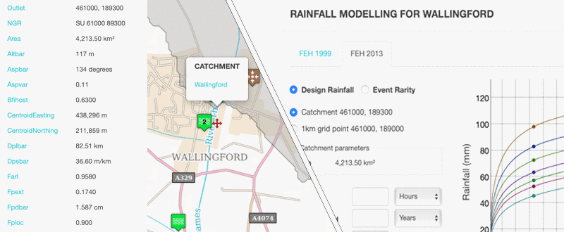
![]() For purchased catchments, you can view and export:
For purchased catchments, you can view and export:
- catchment descriptors (XML, CSV and CD3).
- depth-duration-frequency (DDF) using FEH22 and FEH13 models as well as the legacy FEH99 model, all on a catchment average basis and at the nearest 1 kilometre grid location. The DDF information is plotted on interactive rainfall graphs, which can be exported as a csv or an image.
- catchment boundaries as ESRI shapefiles or PNG images.
- Learn more
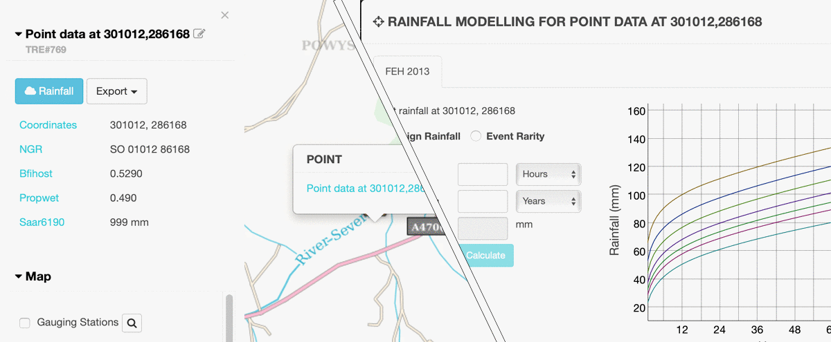
![]() For any purchased point on the map (with 1m resolution), you can view and export:
For any purchased point on the map (with 1m resolution), you can view and export:
- XML point soil and climate descriptors.
- depth-duration-frequency (DDF) using the FEH22 and FEH13 models. The DDF information is plotted on interactive rainfall graphs, which can be exported as a CSV or an image.
- Note the legacy FEH99 rainfall depth/rarity values and DDF parameters (C, D1..3, E & F) are not available for points.
- Learn more
Explore the hydrologically relevant mapping interface to identify the catchment boundaries (over 0.5 km²), and review the variation in annual rainfall (SAAR41-70), hydrogeology and level of urbanisation.
To help in the application of the FEH methods, the interface displays NRFA gauging stations, including Peak Flows classification and links to the station NRFA page.
The FEH Web Service replaces the FEH CD-ROM.
Sign up to use the FEH Web Service
- Individual users
-
As an individual user, you can buy and spend credits as you wish. Your purchases cannot be shared with other user accounts. Sign up here »
- Organisational users
-
As an organisational account user you will have access to all catchment and point data purchased by any users in your organisation. Your organisation nominates one or more lead users who are responsible for purchasing credits and allocating them to users. Please visit our User Guide for further information.
To join an existing organisational account, please contact your lead user who can send you an invite. Alternatively, you can sign up as an individual user first and then contact us to convert the account to an organisational one.
- Educational and Research users
-
Educational and Research Use* of the FEH Web Service is available without a charge being applied for the FEH data. An administration fee of £150 (excluding VAT) is charged to set up an Educational and Research Use account. An initial 1,000 credits will be assigned to each Educational and Research Use account and additional credits may be assigned on request. The credits must all be released to the same Web Service account. If you qualify for this offer we will issue you with a licence certificate along with an invoice for payment. The signed licence certificate and payment must be received before the credits are allocated. Please visit our User Guide for further information.
Please contact us if you would like to set up an Educational and Research account.
* Educational and Research Use means use of the Service for the purpose of teaching and learning, and/or teacher training and which does not involve direct or indirect commercial gain, or for bona fide research to further a body of knowledge, the resulting research papers of which, will be disseminated widely and without delay within the academic community or in the public domain. Such research papers will not be held for the exclusive information or use of the research sponsor or sponsors or in any way restricted from access to the academic community or the wider public.
What is the FEH?
The Flood Estimation Handbook (FEH), with its subsequent updates and FEH Software, provides the industry-standard methods for assessing flood risk in the UK. It offers guidance on the estimation of rainfall and river flood frequency and development site runoff rates across the UK. These are required for:
- Flood risk assessment
- SuDS and traditional drainage system design
- Flood defence planning
- Design of structures such as bridges, culverts and reservoir spillways
- To form the basis of flood risk maps
- Rarity assessment of notable rainfalls or floods
The procedures are clearly explained, and supporting theory and results included.